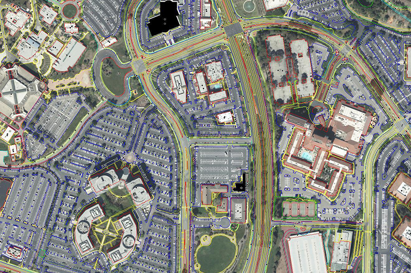
Planimetry
For clients requiring detailed information of ground features such as road edges, utilities, sidewalks, building footprints, shorelines, forestry cutblocks, impermeable surfaces, railways or any other identifiable objects, Geophex Surveys can photogrammetrically collect these features in 3D stereo to ensure their correct identification and positioning (x,y,z). Features can also be collected in 2D from existing orthophotography, but 3D collection from stereo imagery provides much more accurate data and can also include height and elevation information. Any collected features can also have attributes attached to the identifying point, line or polygon that can either be updated from an existing dataset or created new.
Building Footprints
Building footprint data can provide a wide variety of information for urban planning and land use analysis including the number of buildings, building density, structure type (house, multi-family, high-rise, industrial, commercial, etc.), collection date, building height, roof area, etc. If building footprints are updated within the same project area over several years, then change detection can also be applied to determine the locations and type of developments that are occurring.

Impervious Surfaces
Impervious surfaces data is often used for drainage and water runoff analysis and indicates surfaces such as streets, parking lots, rooftops, driveways, sidewalks airports , industrial sites and other areas that are covered by concrete, asphalt or other surfaces that are impenetrable by water. Surfaces can also contain attributes such as Surface Type to provide more detailed information to support infrastructure and development decision making.

Other Planimetric Collection
Geophex Surveys has extensive experience in collecting planimetric features of all kinds to the project specifications required by our clients. Our experienced team of photogrammetrists can accurately update existing data to match specifications, or provide new collection from aerial photography or satellite imagery.